Geography
Scoilnet Maps
https://maps.scoilnet.ie/ Added: 06 Feb 2008 Contributor: Scoilnet Resource type: Guide/notes / Lesson Plan / ToolProvides access to detailed Ordnance Survey Ireland (OSi) maps, including historical maps, and aerial photographs. Enables easy comparison between maps and images. Also allows user to create, copy and adapt resources for their particular use. Two versions available - one for iPads/tablets and a Flash-based version for IWB and PCs/laptops. The World Maps viewer contains superb satellite images/photos of Ireland and is fully accessible from inside and outside the Schools Broadband Network (SBN). The OSi Maps viewer is restricted to the SBN but teachers with a Scoilnet Account can access via log-in.
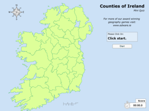
View full descriptionCounties of Ireland - Interactive Quiz
http://www.edware.ie/graphics/ireland_flash.swf Added: 12 Sep 2016 Contributor: Scoilnet Resource type: Assessment / SimulationA lovely interactive quiz to challenge your students ability to identify and locate the counties of Ireland. If students click the incorrect county, a hint will be offered to help with identifying the location. The map will be colour coded at the end of the quiz, correct first time will be green, correct with hint will be orange and incorrect will be red. The quiz is also timed throughout.
View full descriptionHow it maps to the curriculum
Strand: Mapping & Geog Skills
Suggestions for use: Use the animation in class to help students to revise their counties. Allow time for groups to practice completing the quiz together then compete groups using the main board.
Strand: Mapping & Geog Skills
Suggestions for use: Use the animation in class to help students to revise their counties. Allow time for groups to practice completing the quiz together then compete groups using the main board.
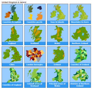
Interactive Geography Quizes - Toporopa
http://www.toporopa.eu/en/index.html Added: 28 Mar 2012 Contributor: Scoilnet Resource type: GameTrain your brain using these interactive Geography quizzes. Quizzes included are on countries, capitals, sea, islands, mountains, rivers, England, Scotland, Wales, Northern Island, Cities in Ireland & UK, Ireland, counties of Ireland, counties of England, districts of Northern Ireland, countries, rivers, flags, mountains, seas, the EU, capitals, monarchies, regions, islands, the eurozone, battles, volcanoes and lakes.
View full descriptionHow it maps to the curriculum
Strand: Natural Environments
Strand unit: Physical Features
Suggestions for use: Very visual resource which would be ideal for the IWB or class computer. Get the children to call out the correct answers or target individual children for answers. Children could also use independently but there are a lot of countries so it could take some time.
Strand: Mapping & Geog Skills
Suggestions for use: Very visual resource which would be ideal for the IWB or class computer. Get the children to call out the correct answers or target individual children for answers. Children could also use independently but there are a lot of countries so it could take some time.
Strand: Natural Environments
Strand unit: Physical Features
Content objective: This resource should enable a child to:
- become familiar with the names and approximate location of a small number of major world physical features
- learn about a small number of the major natural features of Europe
Suggestions for use: Very visual resource which would be ideal for the IWB or class computer. Get the children to call out the correct answers or target individual children for answers. Children could also use independently but there are a lot of countries so it could take some time.
Italy Facts and Pictures -- National Geographic Kids
http://kids.nationalgeographic.com/kids/places/find/italy/ Added: 14 Apr 2014 Contributor: Patrick Coffey Resource type: Guide/notes / Audio / VideoFacts, videos, maps on Italy. The video looks at the changes over time in a particular area of Rome - Trastevere
View full descriptionHow it maps to the curriculum
- 3-4
- SESE Geography
Strand: Human Environments
Strand unit: People and Other Lands
Suggestions for use: Can be used in class on the IWB. Will require a lot of clicking. The video could be played and form the basis of how towns change over time and asking if changes are for the better.
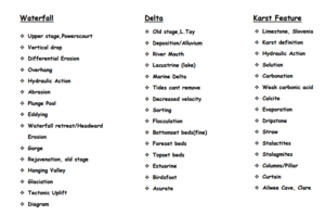
Physical Geography Revision Notes
https://www.scoilnet.ieuploads/resources/18050/17729.pdf Added: 22 Jul 2016 Contributor: Tara Fitzharris Resource type: Guide/notesShort bullet pointed notes for some of the main essay questions asked in the leaving certificate exam about the Physical Geography section of the paper
View full descriptionHow it maps to the curriculum
- SC
- Geography
Strand: C1: Physical Environment
Suggestions for use: This could be used in class as a visual aid when discussing the physical geography section or as an aid to students to help them to construct their own essays on the topic