School level

Pacific Ring of Fire - National Geographic

Added: 05 Jul 2016 Contributor: Tara Fitzharris Resource type: Reference

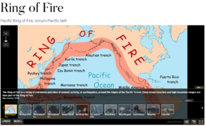
A detailed look at the Pacific Ring of Fire and plate boundaries which includes satellite imagery, aerial photographs and links to interactive maps in which various layers can be added

How it maps to the curriculum

SC
Geography

Strand: C1: Physical Environment

Strand unit: Tectonic

Suggestions for use: This resource can be used as a teacher's aid to help students to visualise the information and as an aid to students preparing research projects on the topic

Meta information

  • Asset type: Online Resource
  • Language: English
  • Rights: Attribution Creative Commons
  • Cost: No
Add a resource

Did you know that your Internet Explorer is out of date

To get the best possible experience using our website we recommend that you upgrade to a newer version or other web browser.

Upgrade your browser now

Registering for a Scoilnet Account – your first step to contributing and sharing

What you need...

To register for a Scoilnet Account you will need to have a Teaching Council number and a roll number for your school in Ireland.

If you already have a Scoilnet Account then you can sign in here.

The benefits...

A Scoilnet account will allow you to upload your resources or weblinks to Scoilnet as well as enabling you to share and add resources to a favourites listing. Users who have a Scoilnet Account will also be able to fully access Scoilnet Maps and Census@School from home.


Register

Add this resource to your Learning Path

You need to login before you can add this resource to a Learning Path

Login